
Shade as Urban Infrastructure
Shade is often treated as an amenity added after streets and public spaces are designed. In hot climates, it is closer to infrastructure: it shapes where people can walk, wait, gather, rest, and remain outdoors.
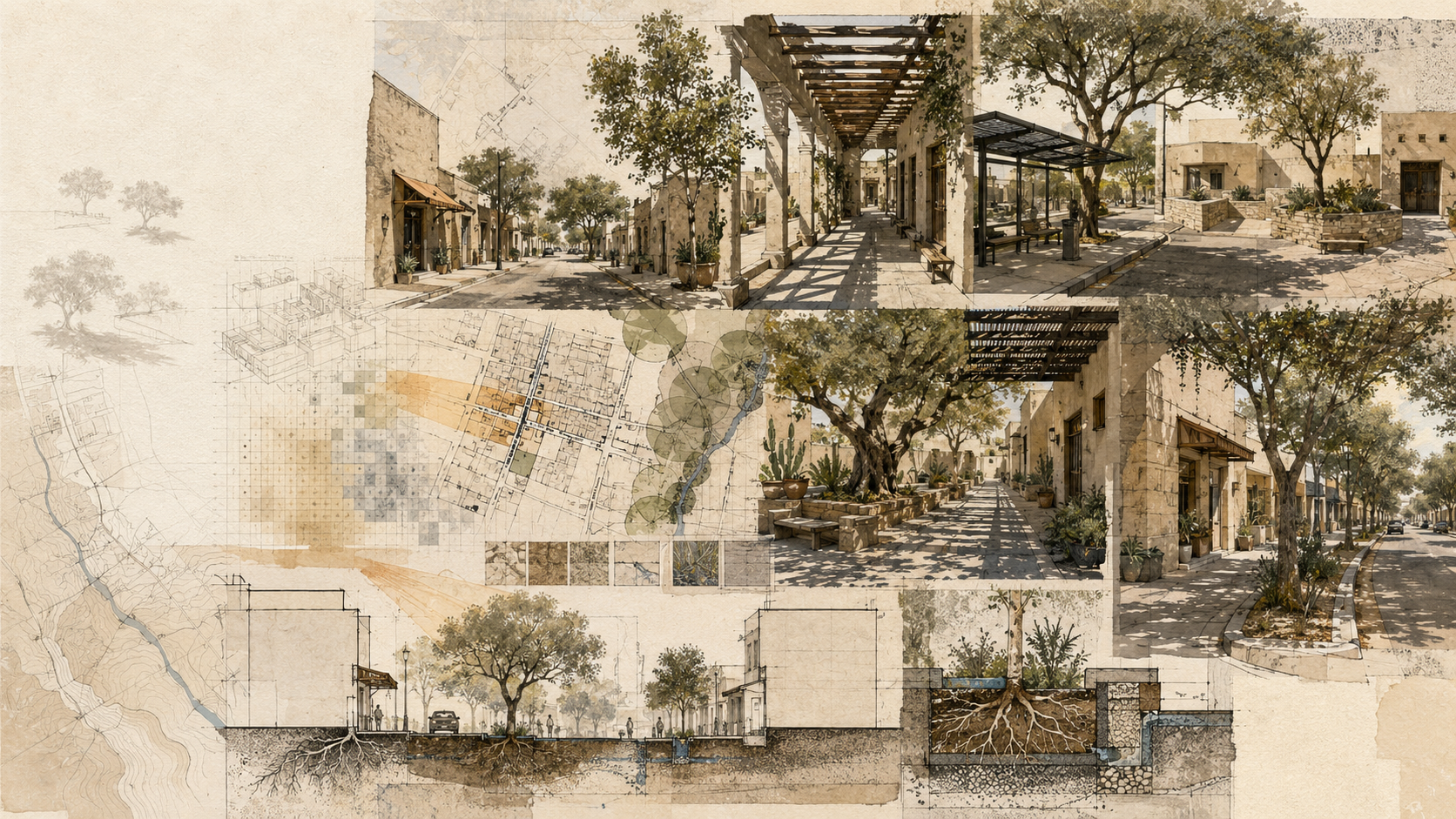
A Field Guide to reading shade as a spatial system rather than a decorative feature. It explains how solar exposure, street geometry, trees, arcades, canopies, surface materials, season, and time of day combine to shape outdoor comfort, and shows how planners can map and design shade networks across streets, transit stops, public spaces, and everyday walking routes.
- Written by
- mbtalafha
- Reading time
- 9 min read
Why this matters
A Field Guide to reading shade as a spatial system rather than a decorative feature. It explains how solar exposure, street geometry, trees, arcades, canopies, surface materials, season, and time of day combine to shape outdoor comfort, and shows how planners can map and design shade networks across streets, transit stops, public spaces, and everyday walking routes.
Shade changes how the city can be used
A street may be physically walkable and still be difficult to use for long periods under intense solar exposure. A bench may exist but remain empty at midday. A bus stop may be correctly located yet uncomfortable to wait at. A plaza may contain enough space for gathering while offering little protection from heat.
These conditions are often treated as matters of comfort or landscape enhancement. In warm and hot climates, they are more fundamental. Shade affects when outdoor spaces can be occupied, how long people can remain in them, and which routes feel practical for everyday movement.
This makes shade a planning question as much as a design question. The relevant unit is not one tree, awning, or arcade. It is the continuous pattern of exposure and protection across the public realm.
Shade is geometry before it is material
Every shaded space begins with a relationship between the sun and an object. Buildings, walls, trees, pergolas, arcades, canopies, and terrain all intercept solar radiation, but the shape and position of the resulting shade change through the day and year.
Street orientation, building height, street width, setbacks, and the position of openings or courtyards can therefore have major consequences for solar exposure. A narrow street may remain shaded for long periods while a broad open road receives direct sun for most of the day. A wall that protects a sidewalk in the morning may provide no useful shade in the afternoon.
The implication is simple: shade should be studied as a moving geometry. A plan showing tree locations or canopy structures without time and orientation can describe what exists while missing when it actually works.
Not all shade performs in the same way
The thermal effect of shade depends on what creates it and what surrounds it. A dense tree canopy can reduce direct solar exposure while also interacting with wind, humidity, and evapotranspiration. A masonry arcade blocks sunlight differently and may release stored heat from surrounding surfaces later in the day. A lightweight canopy may provide immediate protection while leaving nearby paved surfaces fully exposed.
Shade should therefore be assessed together with surface materials, ventilation, surrounding walls, ground cover, and vegetation. A shaded seat beside a heat-storing wall can feel different from a shaded seat beside irrigated planting or open soil.
The planning lesson is to avoid treating shaded and unshaded as the only categories. The quality of the shaded microclimate matters too.
Map where people pause
One of the simplest ways to read shade is to observe where people choose to stop. Look at waiting areas, building entrances, street corners, informal seating, market edges, school gates, taxi stands, transit stops, and places where pedestrians gather before crossing a road.
Compare those locations with the shade available at different times. People may cluster tightly beside a wall, shift benches toward a tree, wait behind a shelter rather than beneath it, or stand several metres away from the formal stopping point because that is where protection is available.
These small adaptations reveal the difference between the planned location of an activity and the microclimatic location where the activity actually becomes comfortable.
Repeated observation at morning, midday, and afternoon can reveal a moving geography of use that a single field visit will miss.
Trees create shade that grows, moves, and changes
Trees are especially valuable because they combine shade with other ecological and landscape functions, but their performance is not immediate or uniform. Canopy size, density, species characteristics, pruning, health, rooting conditions, available soil volume, irrigation, and age all influence the shade a tree can provide.
A newly planted street may contain many trees while offering little meaningful canopy for years. A mature tree may provide extensive shade but occupy a constrained planting area that threatens its long-term health. Closely spaced trees can create a continuous shaded route, while isolated specimens produce small patches separated by exposed pavement.
Planning for tree shade therefore requires thinking in time as well as space. The question is not only where trees can be planted. It is whether the soil, water, maintenance, and protection needed for durable canopy are present.
Built shade can complete the network
Where trees cannot provide sufficient or immediate protection, architecture and street structures can create other forms of shade. Arcades, colonnades, recessed entrances, awnings, pergolas, transit shelters, market canopies, walls, and carefully positioned building volumes can all contribute.
These elements are especially important where underground utilities, narrow sidewalks, limited soil, security requirements, heritage constraints, or intense pedestrian use make large canopy trees difficult to establish.
The useful planning question is not whether tree shade or built shade is preferable in the abstract. It is where each can perform reliably and how they can work together.
A continuous shaded route may depend on mature trees along one block, an arcade along another, a transit canopy at an intersection, and the shadow of a building across a public passage.
Think in routes, not isolated patches
Shade is often provided as individual destinations: a shelter, a pavilion, a cluster of trees, or a covered seating area. Everyday movement depends on continuity.
A person walking to transit may encounter shade at the station but remain exposed for most of the approach. A school entrance may be protected while the waiting area and surrounding sidewalks are not. A public square may include shaded seating but require crossing a large exposed surface to reach it.
Mapping continuous shade changes the unit of analysis. Instead of counting trees or structures, examine the percentage of a walking route that is protected at critical times. Identify long exposed gaps, intersections where pedestrians wait, steep segments where walking is slower, and destinations used by people who may be more sensitive to heat.
This turns shade from a collection of objects into a network.
A field sequence for reading urban shade
Select an everyday route, public space, or activity area rather than an isolated object Record street orientation, building height, setbacks, walls, trees, arcades, shelters, and canopies Observe the same place at more than one time of day where possible Map the actual shaded surface, not only the objects expected to create shade Record where people wait, sit, gather, or alter their path in response to exposure Note surface materials, vegetation, wind exposure, and nearby heat-storing walls or paving Identify exposed gaps between shaded segments of pedestrian routes Distinguish mature canopy from recently planted trees when assessing current performance Compare summer and winter solar conditions where seasonal use matters Return to the plan and map shade as a continuous spatial layer
Select an everyday route, public space, or activity area rather than an isolated object
Record street orientation, building height, setbacks, walls, trees, arcades, shelters, and canopies
Observe the same place at more than one time of day where possible
Map the actual shaded surface, not only the objects expected to create shade
Record where people wait, sit, gather, or alter their path in response to exposure
Note surface materials, vegetation, wind exposure, and nearby heat-storing walls or paving
Identify exposed gaps between shaded segments of pedestrian routes
Distinguish mature canopy from recently planted trees when assessing current performance
Compare summer and winter solar conditions where seasonal use matters
Return to the plan and map shade as a continuous spatial layer
Plan shade as a public system
Once shade is mapped as a network, new planning priorities become visible. A small canopy at a critical crossing may matter more than a large decorative structure in a lightly used plaza. Preserving one mature tree may protect an important walking route. Building setbacks and orientation may create useful afternoon shade without additional structures. Public-space design can connect shaded waiting, seating, movement, and gathering areas rather than treating each separately.
GIS and solar-analysis tools can help model exposure across streets, parcels, and public spaces, but field observation remains essential. A model may not capture temporary structures, recently removed trees, local maintenance conditions, or the exact way people occupy space.
The objective is not continuous darkness. Sunlight is valuable, seasons differ, and urban spaces need a range of conditions. The planning challenge is to ensure that necessary outdoor activities remain possible when solar exposure becomes difficult to tolerate.
Seen this way, shade belongs beside sidewalks, drainage, transit, trees, and lighting as part of the everyday infrastructure of public life.
From knowledge to action
Practical applications
Map summer shade along priority pedestrian routes, transit approaches, school edges, civic spaces, and commercial streets before selecting individual interventions.
Use solar orientation and street geometry during early planning to identify where built form can provide useful shade.
Assess tree planting in terms of future canopy continuity, soil volume, water, maintenance, and long-term survival rather than tree counts alone.
Combine trees with arcades, canopies, shelters, recessed frontages, and other built shade where continuous canopy is difficult to achieve.
Prioritize shade at locations where people are required to wait, including crossings, transit stops, entrances, queues, and pickup areas.
Identify exposed gaps between otherwise shaded street segments and treat continuity as a network-design problem.
Compare shade with pavement, wall materials, vegetation, and ventilation so direct solar protection is not evaluated in isolation.
Use repeated field observations to compare modeled shade with actual occupancy and behavior.
Protect mature trees whose canopy already performs an important public-space function during redevelopment or street reconstruction.
Treat shade provision as part of climate-sensitive public-realm planning rather than as a final landscape embellishment.
Carry into the field
Questions for planners
Where do people need to walk, wait, sit, or gather during the hottest parts of the day?
How much of those routes and activity areas are actually shaded at critical times?
Which existing buildings, walls, trees, arcades, or structures already contribute useful shade?
Where are the longest exposed gaps in otherwise walkable routes?
Are newly planted trees expected to provide a level of shade they cannot yet deliver?
Do proposed tree locations have enough soil, water, and protection to develop durable canopy?
Where could built form or lightweight structures complete a shade network more effectively than additional planting?
Does the shaded condition remain comfortable when surrounding paving, walls, ventilation, and reflected heat are considered?
Would mapping shade as a connected public system change the priorities of the street or public-space plan?
References
Sources for continued reading.
- 01Source ↗
Oke, T. R., Mills, G., Christen, A., and Voogt, J. A. 2017. Urban Climates. Cambridge University Press. A comprehensive synthesis of urban climate processes, including radiation, surface energy exchange, urban form, and thermal environments.
- 02
Erell, E., Pearlmutter, D., and Williamson, T. 2011. Urban Microclimate: Designing the Spaces Between Buildings. Earthscan. A design-oriented synthesis of urban microclimate, solar exposure, built form, vegetation, and outdoor thermal conditions.
- 03
Brown, R. D. 2010. Design with Microclimate: The Secret to Comfortable Outdoor Space. Island Press. A practical guide to designing outdoor environments through radiation, wind, vegetation, and thermal comfort.
- 04Source ↗
Shashua-Bar, L. and Hoffman, M. E. 2000. Vegetation as a climatic component in the design of an urban street: An empirical model for predicting the cooling effect of urban green areas with trees. Energy and Buildings, 31(3), 221-235.
- 05
Emmanuel, R. 2005. An Urban Approach to Climate-Sensitive Design: Strategies for the Tropics. Spon Press. A synthesis of climate-responsive urban form, shading, orientation, and outdoor environmental design.
Connected Knowledge
Continue through the relationships surrounding this record.
Follow what this record touches next.
Cities
Cities are shaped by institutions, infrastructure, markets, households, conflict, care, and everyday negotiation.
Continue →