
Reading Terraces as Slow Infrastructure
A terrace wall is easy to notice. The larger system is harder to see: slope, runoff, soil, infiltration, cultivation, overflow, repair, and the repeated labor that keeps the landscape functioning.
A field guide to reading terraces as landscape infrastructure rather than isolated walls. It explains how terraces alter slope geometry, runoff pathways, soil retention, cultivation, and maintenance, and offers a practical method for interpreting terrace systems through topography, field evidence, historical imagery, and GIS.
- Written by
- mbtalafha
- Reading time
- 8 min read
Why this matters
A field guide to reading terraces as landscape infrastructure rather than isolated walls. It explains how terraces alter slope geometry, runoff pathways, soil retention, cultivation, and maintenance, and offers a practical method for interpreting terrace systems through topography, field evidence, historical imagery, and GIS.
The wall is only the visible part
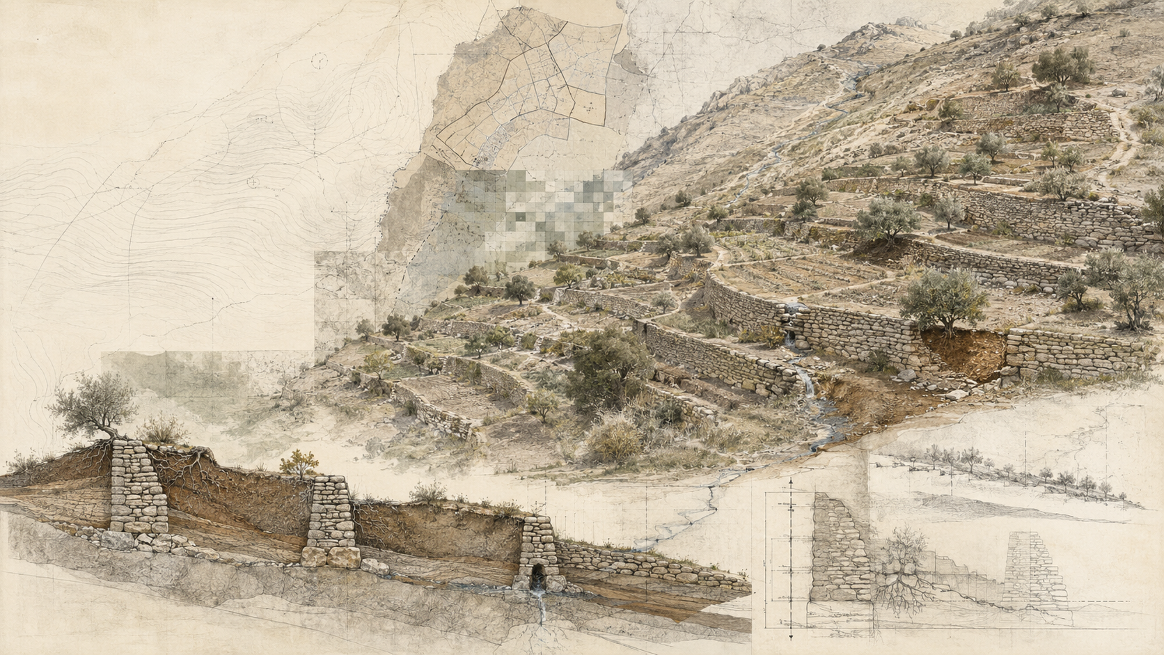
Terraces are often read through their retaining walls. Stone lines crossing a hillside are visually strong, easy to photograph, and easy to map. Yet the wall alone does not explain how the terrace works.
A terrace changes the geometry of a slope. It creates flatter or less steep surfaces, interrupts continuous downslope movement, alters runoff pathways, affects where sediment accumulates, and creates new relationships between soil, water, vegetation, cultivation, access, and maintenance.
For planners and field observers, the useful unit is therefore not the wall. It is the terrace system: contributing slope, bench, retaining structure, drainage route, cultivated surface, access path, overflow point, and the sequence of terraces above and below it.
Read the slope before reading the terrace
Begin with the landform that the terraces modify. Identify the direction of slope, major breaks in gradient, ridges, hollows, shallow drainage lines, exposed rock, and the position of the terrace sequence within the wider hillside.
This matters because two terrace systems that look similar in plan may behave differently if one sits on a convex slope and another in a converging hollow. The area contributing runoff from above can influence erosion, sediment delivery, and the amount of water reaching a terrace. The gradient below can determine what happens if drainage fails or overflow becomes concentrated.
A contour map or terrain model is useful here, but it should be read alongside the field landscape. The first question is not how many terrace walls exist. It is what slope the terraces are trying to reorganize.
Terraces interrupt movement
On an uninterrupted slope, gravity provides a continuous direction for water, soil particles, and loose material to move downslope. Terracing introduces repeated breaks into that continuity.
The effect depends on terrace form, slope, soil, vegetation, rainfall, drainage, maintenance, and land use. A well-functioning terrace can reduce effective slope length, create opportunities for infiltration, retain sediment, and provide a more manageable surface for cultivation. A poorly drained or deteriorated terrace can instead concentrate water, saturate fill, erode around an outlet, or fail at a weakened wall.
This is why terraces should not be described automatically as erosion-control structures simply because they exist. Their present condition and hydrological behavior need to be observed.
Follow water across the bench
The terrace surface often reveals more than the retaining wall. Look at its cross-slope form. Is the bench level, gently inward-sloping, outward-sloping, irregular, or partly collapsed? Where would shallow runoff move during a storm?
Look for small channels, low points, outlets, gaps in walls, pipes, stone-lined drains, erosion marks, sediment fans, moist patches, and vegetation responding to concentrated water. Some terraces disperse water broadly. Others direct it toward particular outlets. Some appear to depend on infiltration within the bench, while others clearly transmit excess water to lower levels.
The important field habit is to follow the water beyond the terrace. If runoff leaves one bench, where does it enter the next? Does it spread again, enter a channel, cross an access track, or concentrate at a damaged wall? Terrace systems are connected vertically as well as horizontally.
Soil is stored as well as cultivated
A terrace can create and preserve a body of soil where an unmodified steep slope might otherwise have a thinner or less stable profile. Over time, sediment may accumulate behind retaining structures, cultivation may redistribute soil, and organic inputs can alter the character of the terrace surface.
This makes the soil profile part of the infrastructure. Where safe and appropriate to observe, note differences in soil depth, stone content, texture, color, rooting, compaction, and visible layering. Eroded edges and maintenance cuts can sometimes reveal how much material has accumulated behind a wall.
Do not assume that every terrace contains deep or uniform soil. Bedrock may lie close to the surface, fill may vary considerably, and centuries of repair or abandonment can produce complicated profiles. The terrace should be read as a constructed landform whose soil history may be as important as its masonry.
Failure exposes the system
A damaged terrace can reveal relationships that are harder to see when everything is intact. Wall bulging may suggest pressure from retained material or water. Scour beside an outlet may indicate concentrated discharge. A breach can expose fill, foundation conditions, wall thickness, drainage details, and construction phases.
Look beyond the immediate failure. Is water arriving from an upslope road, roof, path, or terrace? Has an old drain become blocked? Has cultivation changed? Has vegetation been removed? Has a new wall redirected runoff toward a vulnerable point?
Failure should be documented as a system condition rather than only as a structural defect. Repairing masonry without understanding the water and land-use relationships that contributed to the problem may restore appearance without restoring performance.
Maintenance is part of terrace design
Terraced landscapes depend on repeated intervention. Walls are repaired, drains are cleared, displaced stones are replaced, sediment is redistributed, vegetation is managed, access paths are maintained, and local drainage is adjusted as conditions change.
This work is easy to overlook because it rarely appears on a conventional land-use map. Yet a terrace system that cannot be reached or maintained may deteriorate even if its original construction was technically sound.
During fieldwork, record access routes, repair scars, replacement stone, cleared drainage points, vegetation encroachment, abandoned cultivation, and differences between maintained and neglected sections. These observations help distinguish the designed form from the operational system that keeps it functioning.
A field sequence for reading terrace systems
Map the wider slope before documenting individual walls Identify ridges, hollows, drainage lines, and contributing areas above the terraces Record terrace width, wall height, bench gradient, and visible construction condition Follow runoff across each bench and identify likely outlets or overflow points Look for erosion, sediment accumulation, staining, dampness, and vegetation patterns Record breaches, bulging, collapsed sections, and exposed soil profiles Trace access routes used for cultivation, repair, and maintenance Compare terrace alignment with contour lines and slope direction Use historical imagery to identify abandonment, reconstruction, subdivision, or changing cultivation Return to GIS and map the terraces as a connected system rather than as separate wall segments
Map the wider slope before documenting individual walls
Identify ridges, hollows, drainage lines, and contributing areas above the terraces
Record terrace width, wall height, bench gradient, and visible construction condition
Follow runoff across each bench and identify likely outlets or overflow points
Look for erosion, sediment accumulation, staining, dampness, and vegetation patterns
Record breaches, bulging, collapsed sections, and exposed soil profiles
Trace access routes used for cultivation, repair, and maintenance
Compare terrace alignment with contour lines and slope direction
Use historical imagery to identify abandonment, reconstruction, subdivision, or changing cultivation
Return to GIS and map the terraces as a connected system rather than as separate wall segments
Map terraces as landscape structure
GIS can help reveal patterns that are difficult to understand from a single viewpoint. Terrace alignments can be compared with contours, slope, drainage, soils, land cover, parcel boundaries, access, historical imagery, and areas of recent development.
Historical aerial photography can be especially useful where terrace systems have been abandoned, rebuilt, obscured by vegetation, or fragmented by roads and construction. Terrain models may help identify repeated benches, but resolution and vegetation can affect what is visible.
The planning value comes from treating terraces as spatial structure. A road cutting across a terrace sequence may interrupt drainage and access. Parcel subdivision may separate upper contributing land from lower terraces. Abandonment may change vegetation and maintenance. Urban development may preserve individual walls while severing the relationships that once made the system coherent.
The central question is therefore not simply whether a terrace wall survives. It is whether the landscape relationships around it still function.
From knowledge to action
Practical applications
Map terrace systems together with contours, drainage, soils, access, land use, and parcel boundaries rather than maintaining a wall-only inventory.
Use terrace sequences as part of early site analysis on sloping land where runoff, erosion, access, or heritage may influence planning decisions.
Trace contributing areas above damaged terraces before recommending wall repair or drainage intervention.
Use historical aerial imagery to distinguish long-standing terrace structure from recent reconstruction, abandonment, or development.
Document terrace outlets and overflow pathways so drainage changes caused by roads, walls, grading, or new buildings can be assessed.
Record maintenance access as part of terrace conservation and land-management planning.
Preserve the relationship between upper catchments and lower terrace sequences when evaluating subdivision or infrastructure proposals.
Use field evidence such as sediment, erosion, vegetation, and exposed profiles to test interpretations derived from terrain models.
Treat terrace conservation as landscape management rather than masonry preservation alone.
Carry into the field
Questions for planners
What slope and contributing area does this terrace sequence modify?
Where does runoff enter each bench, and where does it leave?
Are the terraces dispersing water, storing it temporarily, or concentrating it at particular points?
What evidence shows whether the terrace system is currently functioning as intended?
How deep and continuous is the soil retained behind the walls?
Where are maintenance and repair still visible?
What does a failed section reveal about drainage, construction, or changing land use?
Would a proposed road, wall, subdivision, or building interrupt water movement or maintenance access across the terrace sequence?
Are individual walls being preserved while the larger landscape system is being fragmented?
References
Sources for continued reading.
- 01Source ↗
Critchley, W. and Siegert, K. 1991. Water Harvesting: A Manual for the Design and Construction of Water Harvesting Schemes for Plant Production. Food and Agriculture Organization of the United Nations.
- 02Source ↗
Mekdaschi Studer, R. and Liniger, H. 2013. Water Harvesting: Guidelines to Good Practice. Centre for Development and Environment, University of Bern, with WOCAT and partner organizations.
- 03
Morgan, R. P. C. 2005. Soil Erosion and Conservation. Third edition. Blackwell Publishing. A foundational synthesis of erosion processes, slope management, soil conservation, and land-management approaches.
- 04Source ↗
Montgomery, D. R. 2007. Soil erosion and agricultural sustainability. Proceedings of the National Academy of Sciences, 104(33), 13268-13272.
- 05Source ↗
Food and Agriculture Organization of the United Nations. 2017. Voluntary Guidelines for Sustainable Soil Management. Guidance on maintaining and improving soil functions through sustainable land management.
Connected Knowledge
Continue through the relationships surrounding this record.
Follow what this record touches next.
Ideas
Planning concepts and methods influence what planners notice, measure, value, and act upon.
Continue →