
The Wetland Seen From Space: What Greenness Means at Qa al-Azraq
Satellite images can show green returning to Qa al-Azraq. They cannot tell us, by themselves, whether the oasis has returned, or whether the water regime sustaining that recovery is itself sustainable.
A research-led reading of vegetation recovery at Qa al-Azraq in Jordan. Satellite analysis documented a major expansion of vegetation between 2015 and 2025, while bird monitoring, groundwater evidence, and the artificial pumping that sustains part of the wetland reveal a more complicated ecological story. The article asks not only what remote sensing can show about recovery, but what kind of water future can sustain Azraq without reproducing pressure on its depleted aquifer.
- Written by
- mbtalafha
- Reading time
- 8 min read
- Place
- Azraq Wetland Reserve, Zarqa
Why this matters
A research-led reading of vegetation recovery at Qa al-Azraq in Jordan. Satellite analysis documented a major expansion of vegetation between 2015 and 2025, while bird monitoring, groundwater evidence, and the artificial pumping that sustains part of the wetland reveal a more complicated ecological story. The article asks not only what remote sensing can show about recovery, but what kind of water future can sustain Azraq without reproducing pressure on its depleted aquifer.
A Wetland Reappears as Pixels
Wetland recovery is usually imagined at ground level: reeds returning to shallow water, birds gathering at an edge, damp soil becoming vegetated again. At Qa al-Azraq, one of the clearest recent signs of change came from much farther away.
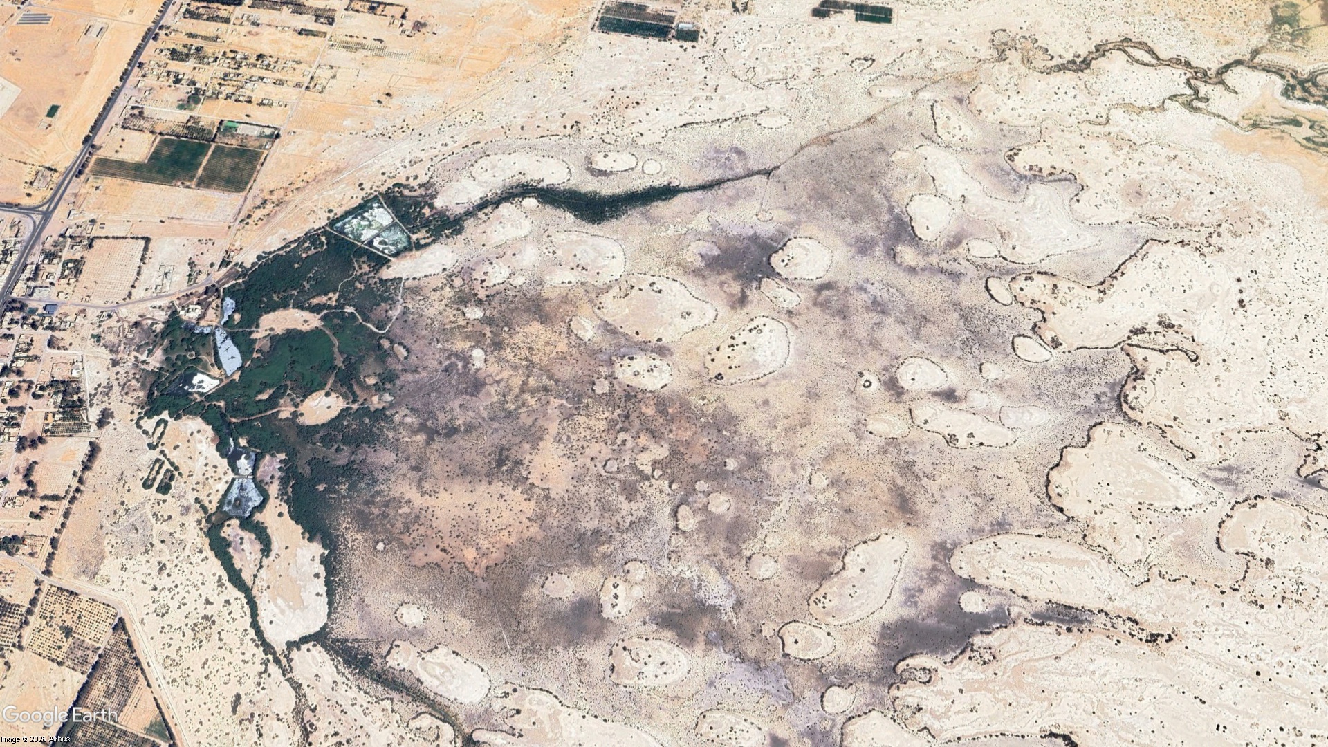
In June 2026, the Royal Society for the Conservation of Nature reported results from a remote-sensing study comparing vegetation across Qa al-Azraq between 2015 and 2025. Using satellite imagery and the Normalized Difference Vegetation Index, or NDVI, the study documented a large expansion of vegetated land within the protected area.
The transformation can be read directly as a change in surface pattern. Areas that registered largely as bare ground in earlier imagery increasingly appear as scattered vegetation, shrubs, grassland, and other plant cover.
But a satellite does not see an oasis in the way a bird, a hydrologist, or a person standing at the wetland edge does. It measures reflected energy from the Earth's surface.
That difference becomes important when greenness begins to stand in for recovery.
Twelve and a Half Square Kilometres of Change
The scale of the reported change is substantial. Vegetated area increased from 2.30 square kilometres in 2015 to 14.83 square kilometres in 2025. That represents an additional 12.53 square kilometres of vegetation, an increase of approximately 545 percent over the ten-year comparison period.
RSCN linked the change to protection and environmental management following the incorporation and fencing of Qa al-Azraq within the reserve. The expansion included scattered vegetation, shrubs, and grassland, while land classified as barren declined by a similar area.
In an arid basin, this is more than a change of colour on a map. Vegetation can stabilize exposed soil, reduce erosion, alter surface roughness, provide food and cover, and expand habitat for insects, birds, and other organisms.
Yet the important word remains vegetation.
The satellite evidence demonstrates a major increase in plant cover. It does not automatically demonstrate the recovery of every ecological process that once defined the Azraq Oasis.
What NDVI Is Actually Seeing
NDVI works because green vegetation interacts with light in a distinctive way. Plants absorb much of the visible red radiation used in photosynthesis while reflecting strongly in the near-infrared portion of the spectrum. Satellite sensors measure this contrast and convert it into an index that can be compared through space and time.
This makes NDVI extremely useful for observing patterns that would be difficult to document consistently on the ground. A decade of vegetation change across a large mudflat can be converted into comparable pixels, mapped, measured, and revisited.
But NDVI measures spectral greenness, not complete ecological condition. It does not directly identify every plant species, measure groundwater depth, describe soil salinity, determine nesting success, reveal aquatic food webs, or tell us whether the hydrological processes sustaining an ecosystem are natural or artificial. In sparsely vegetated drylands, exposed soil can also influence the spectral signal.
The map becomes most useful when its limits remain visible.
It answers one question particularly well: where has green vegetation increased?
Whether the oasis itself is recovering requires more evidence.
Greener Does Not Mean Recovered
Bird monitoring adds another layer to the picture.
Surveys conducted in Azraq Wetland Reserve during 2025 recorded 38 bird species and 317 individual birds. RSCN reported that the number of individuals was substantially lower than in 2024, when approximately 1,000 birds had been recorded, and linked the decline to reduced water availability in Qa al-Azraq.
The vegetation and bird results do not necessarily contradict one another. Vegetation can expand across protected terrestrial and mudflat areas while water-dependent habitat remains limited. A landscape may become greener in one ecological dimension while becoming less suitable for organisms that depend on open water, saturated soils, particular vegetation structures, or aquatic food resources.
This is why ecological recovery rarely fits into one indicator.
A vegetation map, bird survey, groundwater hydrograph, salinity measurement, botanical inventory, water-quality sample, and field photograph each reveal a different part of the system.
None is the wetland by itself.
The Oasis No Longer Fills Itself
The deeper history of Azraq makes the limits of vegetation recovery impossible to ignore.
The original oasis was sustained by groundwater reaching the surface through natural springs. As abstraction increased for agriculture and urban water supply, the groundwater table declined and the natural springs eventually stopped flowing. Much of the original wetland disappeared.
What remains is not sustained entirely by the hydrological system that created the oasis. Groundwater is deliberately pumped from the Azraq aquifer for environmental use in order to maintain part of the wetland reserve.
The Convention on Wetlands records that, after declining groundwater levels stopped natural spring discharge, Jordan's Ministry of Water and Irrigation agreed to pump groundwater from the aquifer to support the wetland. Research on groundwater governance in Azraq similarly describes the remaining wetland as artificially maintained and reports approximately 0.65 million cubic metres of groundwater allocated to environmental use in 2018.
This pumping has an understandable conservation purpose. Without supplementary water, the remaining aquatic habitat could deteriorate further.
But it also produces an uncomfortable ecological paradox: freshwater is being abstracted from the same depleted groundwater system whose over-exploitation helped cause the wetland's collapse.
Keeping the Wetland Alive, Drawing Down the Aquifer
The paradox becomes sharper when the wetland is placed inside the basin's wider water balance.
A detailed study of groundwater use in Azraq estimated total abstraction at 61.2 million cubic metres in 2018 against an official annual safe yield of about 24 million cubic metres. Agriculture accounted for the largest share, followed by groundwater supplied to the national domestic network, while a smaller volume was abstracted specifically to sustain the wetland.
The environmental allocation is therefore only a small part of the basin's overall groundwater problem. Removing it would not solve Azraq's over-abstraction, nor would allowing the remaining wetland to disappear constitute a meaningful water-management success.
Yet the source of that environmental water still matters.
Artificial groundwater support can be justified as an emergency conservation intervention, particularly where the alternative is immediate habitat loss. The harder question is whether an emergency measure should become the permanent hydrological model for restoration.
If the objective is to restore an ecosystem while continuing indefinitely to extract fresh groundwater from a heavily stressed aquifer to sustain it, then ecological restoration and groundwater recovery remain partly in tension.
Could the Wetland Have a More Diverse Water Budget?
Azraq raises a question that deserves to move beyond the simple choice between pumping fresh groundwater and allowing the wetland to dry: could carefully selected non-conventional water sources contribute to the wetland's long-term water budget?
Jordan's National Water Strategy 2023–2040 explicitly seeks to expand non-conventional supplies, including reclaimed water, desalinated water, on-site wastewater treatment and reuse, and water harvesting, while reducing dependence on depleted freshwater resources.
That national direction does not mean that reclaimed wastewater, harvested runoff, brackish water, or another alternative source can simply be diverted into Azraq Wetland Reserve. A Ramsar wetland is not a disposal site, and water that satisfies an irrigation or discharge standard is not automatically ecologically suitable for a sensitive wetland.
Any alternative source would require rigorous assessment of salinity, nutrient concentrations, pathogens, trace contaminants, emerging pollutants, temperature, hydrochemistry, seasonal timing, and effects on plants, invertebrates, fish, birds, microorganisms, and groundwater. Mixing ratios and treatment requirements could matter as much as total volume.
The principle is therefore not substitution at any cost. It is diversification under ecological constraints.
If an appropriately treated and ecologically compatible non-conventional source could safely supply part of the environmental water requirement, fresh groundwater pumping could potentially be reduced while the wetland remains supported. Whether that is technically and ecologically feasible at Azraq should be investigated rather than assumed.
Two Different Measures of Recovery
Seen from space, Qa al-Azraq presents a hopeful image. Vegetation has expanded dramatically across land that had become largely bare, demonstrating what protection, reduced disturbance, and sustained ecological management can accomplish in a dry landscape.
But there are at least two different measures of recovery at Azraq.
The first is visible: more vegetation, stabilized ground, returning habitat structure, and changing patterns across the Qa.
The second lies beneath the surface: whether the water regime sustaining the remaining wetland is moving toward a condition that places less pressure on the aquifer.
These measures should not be confused. The success of vegetation protection deserves recognition even while the hydrological arrangement supporting the wetland remains open to criticism and redesign.
The next phase of restoration may therefore require more than protecting what grows above ground. It may require rethinking where environmental water comes from, how different sources could safely be combined, and how wetland conservation can proceed alongside the recovery of the groundwater system on which Azraq ultimately depends.
From space, green can return before the water system becomes sustainable.
References
Sources for continued reading.
- 01Source ↗
Royal Society for the Conservation of Nature. 2026. الحماية تُعيد الحياة إلى قاع الأزرق: دراسة علمية توثق زيادة الغطاء النباتي بنسبة 545% خلال عشر سنوات. Published 29 June 2026.
- 02Source ↗
Royal Society for the Conservation of Nature. 2026. التزام مستدام بحماية الطيور في الأردن: دراسات وطنية لتعزيز التنوع البيولوجي وصون الموائل الطبيعية. Published 19 March 2026.
- 03Source ↗
Oberhauser, D., Hägele, R., and Dombrowsky, I. 2023. Unravelling hidden factors explaining competition for and overuse of groundwater in Azraq, Jordan: digging deeper into a network of action situations. Sustainability Science 18: 235–249.
- 04Source ↗
Convention on Wetlands. 2017. Azraq Oasis Ramsar Site: how the local community improves and benefits from wetland conservation.
- 05Source ↗
Ministry of Water and Irrigation, Jordan. 2023. National Water Strategy 2023–2040.
- 06Source ↗
U.S. Geological Survey. NDVI, the Foundation for Remote Sensing Phenology.
Connected Knowledge
Continue through the relationships surrounding this record.
Follow what this record touches next.
Land
Land records relationships between ecology, ownership, terrain, history, biodiversity, and development.
Continue →