
The Pipe That Is Mostly Missing: Petra's 116-Metre Lead Conduit
One of the most revealing pieces of Petra's water infrastructure is largely gone. Archaeologists traced it through the smooth hollow it left behind in mortar.
A research note on new work at Petra's 'Ain Braq aqueduct, where detailed survey identified the remains of a roughly 116-metre pressurized lead pipeline alongside a later water-delivery system of channels and terracotta pipes. The discovery is important not only because lead conduits of this kind are rare in the region, but because it reveals a water network that was repeatedly modified, expanded, and technically rethought as the city changed.
- Written by
- mbtalafha
- Reading time
- 5 min read
Why this matters
A research note on new work at Petra's 'Ain Braq aqueduct, where detailed survey identified the remains of a roughly 116-metre pressurized lead pipeline alongside a later water-delivery system of channels and terracotta pipes. The discovery is important not only because lead conduits of this kind are rare in the region, but because it reveals a water network that was repeatedly modified, expanded, and technically rethought as the city changed.
The Discovery Is an Absence
Archaeology often begins with what survives: a wall, a channel, a ceramic pipe, a carved basin.
At Petra, one recent water discovery is compelling for the opposite reason. Much of the object itself is missing.
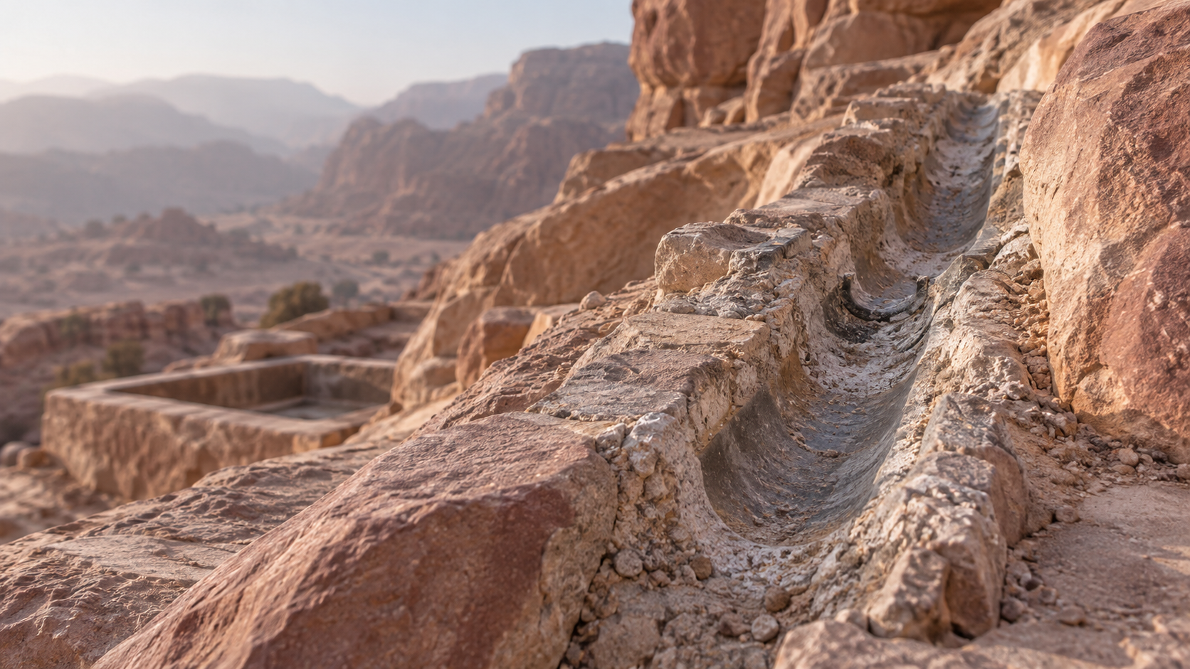
During detailed work on the 'Ain Braq aqueduct at the north-western edge of Jabal al-Madhbah, archaeologist Niklas Jungmann and the Urban Development of Ancient Petra Project documented a smooth, semicircular hollow preserved in mortar. The feature had the regular dimensions and surface expected from a narrow metal pipe rather than the larger, segmented terracotta conduits commonly found at Petra.
The trace could be followed for approximately 116 metres.
Additional evidence strengthened the interpretation. A later survey on az-Zantur identified Nabataean conduit blocks containing hard mortar and surviving lead material consistent with the type of pipe inferred from the earlier imprint.
The result is an unusual archaeological object: a pipeline reconstructed partly from the negative space it left behind.
Why Use Lead Here?
The reconstructed pipe was narrow, approximately 5 to 6 centimetres in outside diameter, and enclosed in mortar. That geometry matters.
Much of Petra's familiar water infrastructure relied on gravity. Spring water could move along carefully graded channels or through terracotta pipes without requiring a fully pressurized system.
The 'Ain Braq line appears to have solved a different problem. Jungmann interprets the lead conduit as a pressurized pipeline functioning as an inverted siphon, allowing water to descend across difficult terrain and rise again toward the reservoir on az-Zantur.
Lead made such a system possible because a continuously sealed metal pipe could withstand pressures that an open channel could not. It was also expensive in raw material, fuel, workmanship, and maintenance.
Its use therefore suggests more than technical knowledge. It indicates that supplying this part of Petra was important enough to justify a comparatively demanding piece of infrastructure.
The Aqueduct Was Rebuilt, Not Simply Built
Perhaps the most interesting result of the survey is that the 'Ain Braq aqueduct no longer reads as one finished engineering solution.
The research area contained nine conduits, a large reservoir behind a high dam, two cisterns, seven basins, and extensive runoff collection features within an area of only about 2,500 square metres. Their physical relationships reveal several phases of modification.
The pressurized lead line belonged to one phase. A later aqueduct arrangement used open channels and terracotta pipes carried across a stone-built substructure toward a small distribution box.
Elsewhere in the same area, runoff systems were modified, basins were connected or bypassed, outlets were sealed, and the retention dam was raised as water-management needs changed.
This is a more interesting picture of ancient infrastructure than a single moment of engineering brilliance.
Petra's water system was being repaired, expanded, abandoned in parts, rerouted, and redesigned.
Petra Was Managing Two Kinds of Water
The newly studied area also makes a useful distinction visible between two water strategies that are sometimes collapsed into one story of Nabataean ingenuity.
One system brought relatively continuous spring water toward the city through the 'Ain Braq aqueduct. Another captured intermittent runoff descending from the sandstone massif.
The runoff network included a substantial retention dam, a reservoir, channels, cisterns, and basins that slowed sediment-laden flows before water entered storage. The aqueduct crossed and modified parts of this older landscape of rainwater management as the site developed.
This coexistence is important. Petra was not sustained by one miraculous technology or by rainfall harvesting alone. UNESCO's description of the World Heritage property emphasizes the surviving combination of diversion works, tunnels, channels, aqueducts, reservoirs, and cisterns, while broader hydraulic studies similarly describe a network that drew on both springs and episodic rainfall.
Water security came from combining sources and technologies rather than depending on one.
A Small Survey Changes the Larger Story
The 116-metre pipeline is visually dramatic as a discovery, but the study's methodological lesson may be more important.
The new interpretation came from examining a relatively small piece of Petra at high resolution. Mortar surfaces, blocked openings, changes in channel alignment, sediment deposits, construction joints, elevations, basins, and fragments that might look insignificant in isolation were read together as a sequence.
That approach revealed a water landscape more complicated than earlier large-scale maps suggested.
It also leaves questions open. The precise dating of the lead phase is not securely established. A connection with major development during the reign of Aretas IV and with the Great Temple and Garden and Pool Complex is plausible, but remains a hypothesis requiring further evidence. Parts of the route inside the city are also still uncertain.
That uncertainty is part of the value of the discovery.
Petra's hydraulic archaeology is not a solved system waiting to be admired. It is still being reconstructed, sometimes from a pipe that is no longer there.
References
Sources for continued reading.
- 01Source ↗
Jungmann, N. 2026. Rediscovering the 'Ain Braq aqueduct: new insights into Petra's urban water management. Levant 58(1): 61-79. Published online 23 December 2025.
- 02Source ↗
UNESCO World Heritage Centre. Petra. The World Heritage description identifies the diversion dam, Muthlim tunnel, water channels, aqueducts, reservoirs, and cisterns as outstanding examples of ancient water engineering.
- 03Source ↗
Ortloff, C. R. 2005. The Water Supply and Distribution System of the Nabataean City of Petra (Jordan), 300 BC-AD 300. Cambridge Archaeological Journal 15(1): 93-109.
Connected Knowledge
Continue through the relationships surrounding this record.
Follow what this record touches next.
Ideas
Planning concepts and methods influence what planners notice, measure, value, and act upon.
Continue →