
Reading Ancient Water Systems as Landscape Infrastructure
A channel, cistern, terrace, shaft, or dam is rarely the whole water system. The larger story is written into the slopes, catchments, routes, soils, storage spaces, and maintenance paths that connect these structures.
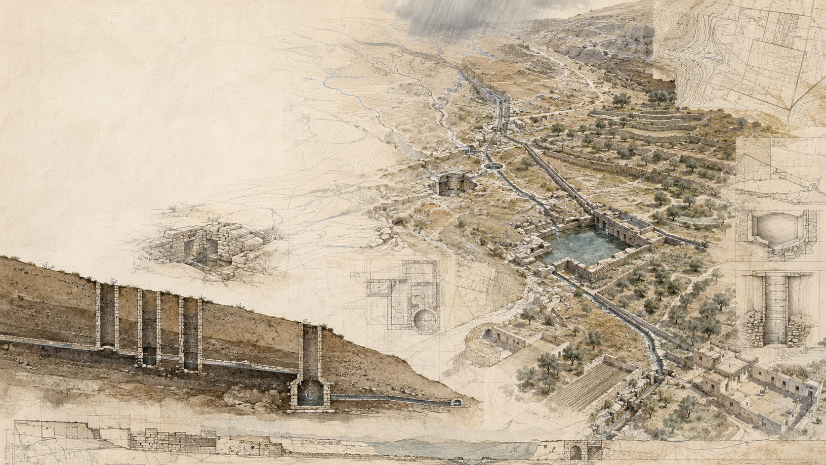
A field guide to reading ancient water systems as complete landscape infrastructures rather than isolated monuments. It offers a method for tracing water from source to use, distinguishing capture from conveyance and storage, recognizing the role of topography and maintenance, using GIS carefully, and interpreting surviving remains without overstating their original function.
- Written by
- mbtalafha
- Reading time
- 10 min read
Why this matters
A field guide to reading ancient water systems as complete landscape infrastructures rather than isolated monuments. It offers a method for tracing water from source to use, distinguishing capture from conveyance and storage, recognizing the role of topography and maintenance, using GIS carefully, and interpreting surviving remains without overstating their original function.
The structure is only the visible clue
Ancient water systems are often encountered as objects: a stone-lined channel, a rock-cut cistern, a terrace wall, a reservoir, a vertical shaft, or the remains of a diversion structure. These features are visually compelling, but reading them one by one can obscure the system that once connected them.
Water harvesting in drylands has historically depended on relationships among catchments, runoff, topography, conveyance, storage, soils, and users. Archaeological research across Mediterranean and Western Asian drylands likewise treats water harvesting as a family of linked strategies rather than a single type of structure.
A useful field method therefore begins with a change of scale. Instead of asking only what a structure is, ask what water had to reach it, where that water could have come from, what happened after it arrived, and what other landscape elements were necessary for the system to work.
Start with the source and the contributing landscape
Every water system begins with a source, but source does not always mean a spring, river, or well. In dry landscapes, the source may be rainfall falling across a much larger contributing area and becoming runoff only after it encounters particular slopes, surfaces, soils, and storm conditions.
This makes the catchment part of the infrastructure. A hillside above a terrace, a rocky surface feeding a channel, a wadi delivering episodic floodwater, or an upland aquifer feeding a gravity system can matter as much as the built feature at the point of use. Water-harvesting literature emphasizes the importance of matching collection techniques to local rainfall, runoff, terrain, soils, demand, and management conditions.
In the field, begin above the structure whenever access and safety allow. Trace the land that could contribute water. Record slope direction, exposed rock, soil depth, drainage lines, saddles, depressions, and evidence of concentrated flow. The aim is not to prove function immediately. It is to reconstruct the physical possibilities that made water capture feasible.
Separate capture, conveyance, storage, and use
Ancient water systems become easier to interpret when their functions are separated conceptually. Capture intercepts water. Conveyance moves it. Storage holds it across time. Distribution directs it toward people, animals, fields, gardens, workshops, or other uses. Drainage and overflow remove water that cannot be retained.
One surviving feature may perform more than one of these roles, but keeping the categories separate prevents a common interpretive shortcut: assuming that every channel is irrigation, every basin is storage, or every wall across a slope was built only to retain soil.
Archaeological syntheses of dryland water harvesting distinguish groundwater harvesting, runoff harvesting, and floodwater harvesting, each with different relationships to topography and water movement.
On a field sketch or GIS layer, draw the likely sequence explicitly: source or catchment, interception point, route, storage or spreading area, destination, and overflow. Gaps in that chain are useful. They show where evidence is missing and where further survey may be more valuable than a confident label.
Topography is part of the technology
Gravity is one of the most persistent organizing forces in water infrastructure. Slight differences in elevation can determine whether water reaches a reservoir, whether a channel can maintain flow, whether runoff spreads across a field, or whether a storage system can serve lower ground.
This is why topographic reading should accompany architectural description. A channel with no visible water today may still reveal its logic through gradient. A line of shafts may indicate an underground route that cannot be understood from the surface opening alone. A terrace system may be more intelligible when mapped against the contributing slope and ephemeral drainage network.
Research on long-lived gravity-fed systems shows that their operation depended not only on construction but also on careful alignment, access, cleaning, and relationships between upland water sources and lower settlement or agricultural areas.
Contour maps, precise elevation data, longitudinal profiles, and field levels can therefore reveal relationships that masonry alone cannot.
Look for the traces of maintenance
Water infrastructure is rarely a build-once technology. Channels silt up. Intakes clog. Terrace walls fail. Shafts require access. Cisterns accumulate sediment. Floods damage diversion works. Masonry is repaired, extended, bypassed, or abandoned.
These processes leave evidence. Changes in construction technique, blocked openings, secondary plaster, patched walls, sediment lenses, access paths, cleaning shafts, rebuilt channel edges, and differently weathered surfaces may indicate repeated intervention. Such traces can be as important as the original construction because they reveal how a system was kept operational.
Studies of historic water systems have repeatedly emphasized the connection between physical infrastructure and the social arrangements required to maintain it. Long-term operation can depend on labor, rights, responsibilities, knowledge transfer, and agreed rules for access to water.
For planners and heritage practitioners, maintenance should therefore be mapped as part of the system. Ask not only how water moved, but also how people reached the structures, removed sediment, repaired failures, and coordinated shared infrastructure.
Use GIS to reconstruct relationships, not to manufacture certainty
GIS is particularly valuable for ancient water landscapes because many systems are larger than a single field of view. Elevation models can help identify contributing areas, gradients, drainage routes, and possible relationships between scattered remains. Historical imagery and remote sensing can reveal alignments that are difficult to recognize at ground level. Mapping can also connect archaeological features with geomorphology, soils, settlement patterns, and modern disturbance.
But spatial alignment is not proof of hydraulic connection. Two features may lie on the same slope and belong to different periods. A depression may be natural rather than engineered. A channel-like line may be a later boundary, road, or erosion feature. Even a plausible modeled flow path may not represent the route used historically.
The strongest workflow moves repeatedly between map and field. Use GIS to generate questions, locate gaps, compare elevations, and identify candidate connections. Then return to the ground to inspect construction, stratigraphy, sediment, gradient, and physical continuity.
The map should preserve uncertainty rather than hide it. A tentative connection, probable catchment, or possible route should remain distinguishable from a feature confirmed through field evidence.
A field sequence for reading an ancient water system
Locate the highest plausible water source or contributing catchment Map natural drainage before interpreting built drainage Record elevation and gradient wherever function depends on gravity Separate capture, conveyance, storage, distribution, use, and overflow Trace physical connections instead of assuming them from proximity Look for sediment, erosion, plaster, repairs, blocked openings, and maintenance access Record construction differences that may indicate multiple phases Compare the system with soils, fields, settlement areas, and topography Use GIS to test relationships, then verify critical links in the field Mark uncertain interpretations explicitly rather than converting them into finished facts
Locate the highest plausible water source or contributing catchment
Map natural drainage before interpreting built drainage
Record elevation and gradient wherever function depends on gravity
Separate capture, conveyance, storage, distribution, use, and overflow
Trace physical connections instead of assuming them from proximity
Look for sediment, erosion, plaster, repairs, blocked openings, and maintenance access
Record construction differences that may indicate multiple phases
Compare the system with soils, fields, settlement areas, and topography
Use GIS to test relationships, then verify critical links in the field
Mark uncertain interpretations explicitly rather than converting them into finished facts
Do not confuse survival with original function
Ancient water landscapes are palimpsests. Some structures survive because they were robust. Others were repaired or reused for centuries. Some elements disappear because they were made from earth, timber, vegetation, or lightly built masonry. Modern roads, pumping, cultivation, quarrying, settlement, and drainage can further alter the original relationships.
The visible landscape is therefore selective. A large reservoir may dominate interpretation simply because it survives, while the catchment treatments or small channels that supplied it have disappeared. A terrace wall may remain after the diversion that once fed it is gone. A shaft line may survive even where the outlet and distribution network have been modified.
Research on ancient water systems shows that infrastructure can evolve through long sequences of expansion, repair, institutional change, abandonment, and reuse.
A careful field guide should distinguish observation from interpretation. Record what is physically present first. Then state the proposed function, the evidence supporting it, plausible alternatives, and the level of confidence.
Read heritage as a working relationship between land and water
Ancient water systems are valuable not because they provide ready-made solutions for contemporary water scarcity, but because they preserve long records of adaptation to particular landscapes. They show how communities worked with gradients, episodic runoff, groundwater, storage, soils, labor, and maintenance under specific environmental and social conditions.
Modern water-harvesting guidance similarly stresses that effective interventions depend on site conditions and management rather than the simple transfer of a technique from one place to another.
For planning, the practical lesson is methodological. Study the relationship before copying the object. Ask why a structure was placed there, what landscape supplied it, what demands it served, how excess water moved, what maintenance it required, and what limits shaped its operation.
This approach also changes heritage conservation. Protecting a cistern while destroying its catchment, preserving a channel while severing its gradient, or conserving a terrace while allowing the contributing drainage to be regraded can preserve masonry while erasing function. The landscape connection is part of the heritage.
From knowledge to action
Practical applications
Map archaeological water features together with contours, drainage, soils, settlement, and land use rather than maintaining a separate inventory of structures.
Use longitudinal profiles to test whether proposed hydraulic connections are physically plausible.
Record catchments and overflow destinations as part of heritage documentation, not only the built storage or conveyance feature.
Separate observed fabric from interpreted function in field notes and GIS attributes.
Add confidence levels to reconstructed channels, catchments, and system relationships so uncertain connections remain visible.
Use historical aerial imagery and terrain models to identify features that have been altered by modern roads, cultivation, grading, or development.
Include maintenance access, sediment removal, repair evidence, and operational responsibilities when interpreting long-lived water infrastructure.
Assess development proposals for their effect on the hydrological relationships surrounding heritage structures, even where the structures themselves are outside the project footprint.
Use ancient systems as prompts for contemporary landscape analysis, while testing modern applications against present hydrology, water quality, governance, demand, and environmental conditions.
Carry into the field
Questions for planners
What landscape supplied water to this feature, and is that contributing area still legible?
Which parts of the system captured water, which moved it, which stored it, and which distributed it?
Does the proposed hydraulic interpretation make sense when elevation and gradient are checked?
What evidence distinguishes engineered water infrastructure from natural drainage or later land use?
Which missing or poorly preserved components would have been necessary for the system to function?
Where are repair, cleaning, access, sediment removal, or rebuilding visible in the surviving fabric?
How much of the interpretation depends on the survival of large masonry features while smaller components have disappeared?
Would conserving the structure without its catchment, route, or surrounding terrain preserve the heritage value that matters?
What can be learned from the system's relationship to landscape without assuming that an ancient technique should be copied directly today?
References
Sources for continued reading.
- 01Source ↗
Beckers, B., Berking, J., and Schütt, B. 2013. Ancient Water Harvesting Methods in the Drylands of the Mediterranean and Western Asia. eTopoi: Journal for Ancient Studies, 2, 145-164.
- 02Source ↗
Vetter, T. and Rieger, A.-K. 2019. Ancient water harvesting in the Old World Dry Belt: synopsis and outlook. Journal of Arid Environments, 169, 42-53.
- 03Source ↗
Mekdaschi Studer, R. and Liniger, H. 2013. Water Harvesting: Guidelines to Good Practice. Centre for Development and Environment, University of Bern, with WOCAT and partner organizations. ISBN 978-3-905835-35-9.
- 04Source ↗
Wilkinson, T. J., Boucharlat, R., Ertsen, M. W., Gillmore, G., Kennet, D., Magee, P., Rezakhani, K., and De Schacht, T. 2012. From human niche construction to imperial power: long-term trends in ancient Iranian water systems. Water History, 4(2), 155-176.
- 05Source ↗
Manuel, M., Lightfoot, D., and Fattahi, M. 2018. The sustainability of ancient water control techniques in Iran: an overview. Water History, 10, 13-30.
Connected Knowledge
Continue through the relationships surrounding this record.
Follow what this record touches next.
Ideas
Planning concepts and methods influence what planners notice, measure, value, and act upon.
Continue →Continue Through This World
Related Knowledge
Reading Terraces as Slow Infrastructure
water · land · ideas
Ancient Water Systems Were Built to Be Maintained
water · land · ideas
Mapping Sanitation Vulnerability in Jordan
water · cities · land
Shade as Urban Infrastructure
cities · land · ideas
The Wetland Seen From Space: What Greenness Means at Qa al-Azraq
Azraq Wetland Reserve