
Why Sections Reveal What Plans Hide
A plan can show where things are. A section can show how ground, water, buildings, vegetation, infrastructure, and people actually meet.
A Field Guide to the section drawing as a planning instrument rather than a presentation graphic. It explains how sections reveal vertical relationships that maps can flatten, how to choose meaningful transects, how to combine field observation with GIS and topographic data, and how sectional thinking can expose hydrological, ecological, infrastructural, and urban relationships before planning decisions are fixed.
- Written by
- mbtalafha
- Reading time
- 8 min read
Why this matters
A Field Guide to the section drawing as a planning instrument rather than a presentation graphic. It explains how sections reveal vertical relationships that maps can flatten, how to choose meaningful transects, how to combine field observation with GIS and topographic data, and how sectional thinking can expose hydrological, ecological, infrastructural, and urban relationships before planning decisions are fixed.
Plans flatten relationships
Planning depends heavily on the plan view. Parcels, roads, buildings, waterways, zoning, vegetation, infrastructure, and property boundaries are usually mapped from above because the plan is efficient at showing distribution, adjacency, and area.
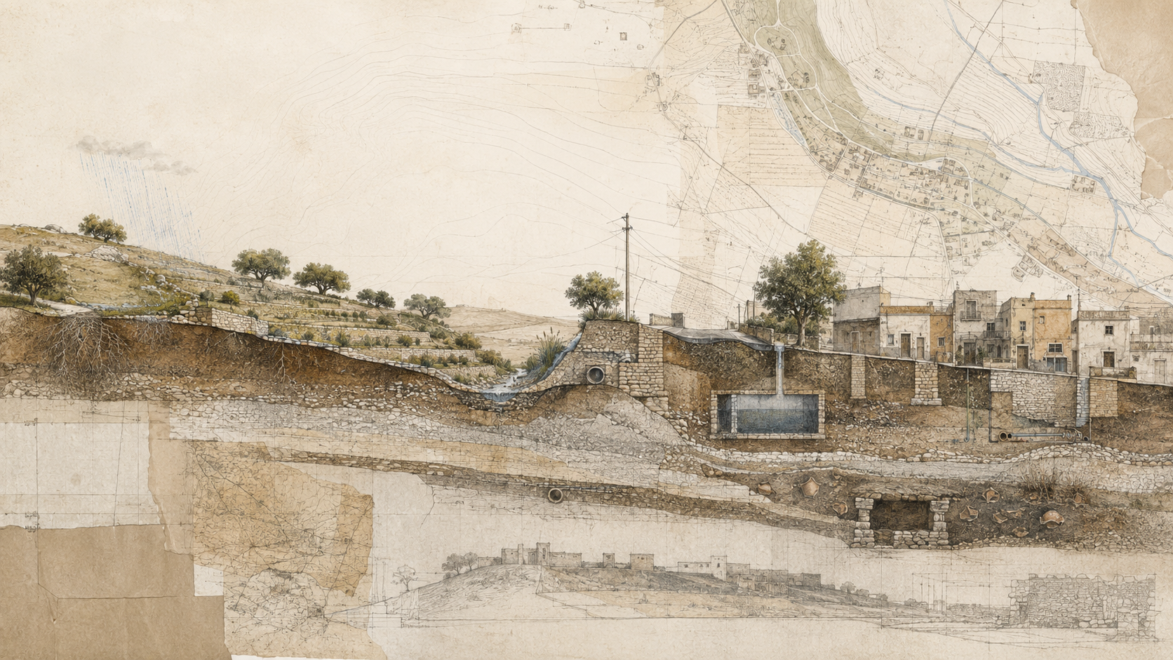
But many important spatial relationships are vertical. A road sits above or below surrounding land. A retaining wall interrupts a slope. Stormwater travels toward a low point. Tree roots occupy soil beneath paving. A buried pipe crosses beneath a building setback. A terrace stores soil behind a wall. A neighborhood climbs a hillside while drainage follows an entirely different geometry.
A section cuts through this complexity. It does not replace the map. It reveals a different class of relationships that the map tends to compress.
A section is an argument about connection
Every section is selective. The line chosen for the cut determines what becomes visible and what disappears. A section through a street can reveal enclosure, shade, drainage, utilities, slope, building frontage, and pedestrian space. A section through a valley can reveal catchment structure, soil, vegetation, settlement, floodplain relationships, and infrastructure crossings.
This means a section is not simply a neutral drawing of reality. It is an analytical argument. The choice of section line expresses a question: what relationship needs to be understood?
The strongest analytical sections are therefore not chosen because they produce the most attractive composition. They are chosen because they pass through a meaningful conflict, transition, threshold, or system.
Topography becomes spatial structure
Contours describe elevation in plan, but the sectional cut turns those intervals into visible landform. Ridges, terraces, embankments, escarpments, valleys, benches, cut slopes, and depressions become easier to compare when they are drawn along a common vertical plane.
This matters for planning because apparently short distances in plan can contain significant elevation change. Two parcels may share a boundary while sitting several metres apart vertically. A proposed road may require extensive cutting or filling even when its alignment appears simple from above. A building platform may interrupt a previously continuous slope.
Sections allow topography to become part of the planning argument rather than a background layer. They make the physical consequences of occupying the land harder to ignore.
Water becomes visible between surfaces
Water is one of the clearest reasons to think sectionally. Surface runoff responds to gradient. Groundwater occupies depth. Drainage infrastructure passes beneath streets. Cisterns sit below roofs and courtyards. Culverts connect channels across embankments. Terraces slow or redirect water as it moves downslope.
A plan can map each of these components, but a section can show their vertical relationship at once. It can reveal whether an overflow sits above or below a receiving landscape, whether a road interrupts a natural drainage path, whether a retaining wall creates a low point, or whether a proposed development platform occupies the path between an upper catchment and lower ground.
The value is not hydraulic calculation. The value is spatial comprehension. A section helps the planner see which hydrological questions should be investigated before detailed engineering begins.
Choose the cut where the landscape changes
A useful field section often crosses more than one condition. Look for places where dense urban fabric meets open land, where a road crosses a drainage line, where a terrace sequence descends toward development, where a valley narrows, where a retaining wall changes the slope, or where infrastructure occupies a natural low point.
Walk the proposed section line before drawing it when access allows. Record changes in elevation, surface material, vegetation, wall height, building setbacks, drainage, exposed soil, utilities, access, and land use. Photograph both along the line and across it.
The purpose is not to document every object. It is to understand the sequence of conditions. What changes first? What continues across the transition? Which relationships are interrupted? Where does water move? Where does visibility open or close? Where does access become difficult?
The section should begin as a question in the field before it becomes a graphic.
Combine field evidence with GIS
GIS makes sectional analysis more powerful because terrain, cadastral data, land cover, building footprints, roads, hydrology, and infrastructure can be brought into a common spatial framework. Elevation profiles can be generated from digital terrain models, while field observations can be attached to precise locations along the section line.
The resulting drawing should not be treated as automatically accurate. Terrain resolution may smooth small walls, curbs, channels, or terrace breaks. Building datasets may omit height. Underground infrastructure may be incomplete. Vegetation can distort surface models derived from some remote-sensing techniques.
A strong workflow moves in both directions. GIS establishes the broad geometry. Field observation corrects, enriches, or questions it. The revised section then becomes a tool for returning to the map with a better understanding of what the plan view concealed.
Draw what lies below the visible surface
The ground line is not the end of the landscape. Beneath it are soils, foundations, roots, utilities, groundwater, archaeological deposits, retaining structures, storage tanks, tunnels, pipes, and geological layers.
Sectional representation allows these hidden systems to be considered alongside what is visible above ground. This is especially important where planning decisions depend on excavation, drainage, tree establishment, heritage, slope stability, water storage, or underground infrastructure.
Not everything below ground is known with equal confidence. A measured pipe depth is different from an assumed groundwater level. A documented archaeological layer is different from a possible buried feature. Analytical sections should distinguish observed, surveyed, modelled, inferred, and unknown conditions rather than drawing all information with equal certainty.
A practical sequence for building an analytical section
Start with a planning question rather than an arbitrary line Choose a cut that crosses a meaningful transition, conflict, or system Extract terrain and basic spatial data from GIS Walk the line and record changes in slope, surface, vegetation, drainage, access, and built form Add walls, roads, buildings, channels, utilities, and other elements that alter the vertical relationship Distinguish visible conditions from buried or inferred conditions Extend the section far enough to show where water, access, ecology, or infrastructure comes from and where it continues Compare the section with cadastral, hydrological, ecological, and land-use layers Mark uncertainty instead of giving unverified information the appearance of precision Use the finished section to test planning decisions, then revise the plan
Start with a planning question rather than an arbitrary line
Choose a cut that crosses a meaningful transition, conflict, or system
Extract terrain and basic spatial data from GIS
Walk the line and record changes in slope, surface, vegetation, drainage, access, and built form
Add walls, roads, buildings, channels, utilities, and other elements that alter the vertical relationship
Distinguish visible conditions from buried or inferred conditions
Extend the section far enough to show where water, access, ecology, or infrastructure comes from and where it continues
Compare the section with cadastral, hydrological, ecological, and land-use layers
Mark uncertainty instead of giving unverified information the appearance of precision
Use the finished section to test planning decisions, then revise the plan
Use sections to test decisions before they become fixed
A section becomes especially valuable when it is used before design decisions are complete. A proposed road can be tested against slope and drainage. A development platform can be compared with existing terrain. Tree planting can be considered alongside soil depth and underground infrastructure. A terrace can be examined together with its retaining wall, runoff, access, and lower slope.
Sections are also useful for exposing external consequences. A wall constructed within one parcel can alter drainage on another. A road embankment can interrupt ecological or pedestrian continuity. A building placed on high ground can change views, shade, wind exposure, and access far beyond its footprint.
The section turns these relationships into something that can be discussed. It makes planning less dependent on isolated objects and more attentive to how decisions occupy a continuous landscape.
From knowledge to action
Practical applications
Use analytical sections during early site review whenever topography, drainage, walls, terraces, building height, or underground infrastructure influence planning decisions.
Pair cadastral plans with sections where property boundaries divide continuous slopes, catchments, ecological systems, or access routes.
Generate preliminary terrain profiles from GIS, then correct them with field observations of small but important features such as curbs, channels, walls, and terrace breaks.
Use sections to test how proposed roads, platforms, retaining structures, and buildings alter existing ground rather than evaluating footprint alone.
Draw surface and subsurface systems together when assessing cisterns, drainage, tree planting, utilities, heritage, or excavation.
Extend sections beyond project boundaries where water, access, views, infrastructure, or ecological relationships continue into surrounding land.
Distinguish surveyed, observed, modelled, inferred, and unknown conditions so graphic precision does not imply false certainty.
Use repeated sections across a larger site to compare changing conditions instead of relying on one representative cut.
Return from sectional analysis to the plan and revise boundaries, alignments, setbacks, open space, or infrastructure where vertical relationships reveal problems.
Carry into the field
Questions for planners
What relationship would remain invisible if this place were studied only in plan?
Where should the section line pass if the objective is to understand the most important transition or conflict?
How does elevation change across the site, and which planning decisions are sensitive to that change?
Where does water move above, across, or beneath the ground line?
Which apparently adjacent elements are actually separated vertically?
What lies below the visible surface that could influence planning or design?
Which small field conditions are missing from available terrain or GIS data?
What information in the section is measured, what is inferred, and what remains unknown?
Would the planning decision change if its consequences were evaluated in section rather than only by footprint?
References
Sources for continued reading.
- 01
McHarg, I. L. 1969. Design with Nature. Natural History Press. A foundational work in ecological planning that demonstrates the value of reading environmental systems together before making spatial decisions.
- 02
Spirn, A. W. 1984. The Granite Garden: Urban Nature and Human Design. Basic Books. A foundational account of the city as a landscape shaped by interconnected natural and built processes.
- 03Source ↗
Spirn, A. W. 1998. The Language of Landscape. Yale University Press. The book develops landscape as a legible system of form, process, history, and cultural meaning.
- 04
Corner, J. 1999. The Agency of Mapping: Speculation, Critique and Invention. In D. Cosgrove, editor, Mappings. Reaktion Books. The essay examines mapping as an active practice of spatial interpretation rather than a neutral record.
- 05Source ↗
U.S. Geological Survey. What is a topographic map? Guidance explaining how contours represent elevation, slope, and landform on topographic maps.
Connected Knowledge
Continue through the relationships surrounding this record.
Follow what this record touches next.
Cities
Cities are shaped by institutions, infrastructure, markets, households, conflict, care, and everyday negotiation.
Continue →